Search
Nusrat Jahan, Agyiri, Michael, Jha, Prashant, Sehgal, Vinit, Conger, Stacia
Nusrat Jahan, Michael Nii Attoh Agyiri, Frank Anyoka Adekilae, Parvin Momenian, Prashant Jha, Stacia Conger and Vinit Sehgal
The Louisiana Climate and Digital Agriculture Network, known as LaCADIAN, is LSU AgCenter’s recently established statewide monitoring network designed to help farmers, extension agents and researchers better understand the weather, soil and crop conditions affecting Louisiana agriculture. LaCADIAN is operated as a network of 24 automated stations that continuously monitor environmental conditions across key strategic locations within the state.
Louisiana weather conditions are dynamic and highly variable, which can change a farmer’s plans with a moment’s notice during the crop season. Localized rainfall can flood certain fields while others nearby still require irrigation. During seasonal transitions, air temperatures can swing by more than 40 degrees in a single day, and torrential downpours can stunt seedlings or limit harvest of a mature crop. Chemical drift can also happen with shifts in wind speed or direction, affecting application efficiency, economics and even neighborly relations when chemicals move beyond the intended field. Weather information is critically important to producers making decisions about planting, irrigation, drainage, chemical applications and harvest.
LaCADIAN stations are placed across important farming and ecological landscapes, including AgCenter research stations and the Mississippi River Alluvial Plain. Many are concentrated in northeast and central Louisiana, where row-crop agriculture, alluvial soils, water management and flooding risk are closely linked. Others extend into northwest, southwest and southeast Louisiana to capture differences among inland, upland and river-influenced areas. This placement is intentional: Louisiana agriculture is not one uniform system, and neither is its climate.
The project is led by Vinit Sehgal at the AgCenter and is supported by funding from the U.S. Department of Agriculture’s Natural Resources Conservation Service (USDA NRCS). AgCenter faculty Stacia Conger directs irrigation management, extension and outreach activities, while Prashant Jha manages the precision weed management aspects of the project.
Each station collects measurements every 15 minutes, which are processed and made available through an open-access public dashboard in hourly and daily summary formats. The aboveground sensors measure rainfall, air temperature, relative humidity, wind, sunlight and barometric pressure, among several other variables. Specialized sensors also provide crop greenness and surface temperature to help detect growth and early stress. The underground sensors measure soil moisture, matric potential (relative availability of the amount of water that is in the soil for plant uptake or use), temperature and salinity at multiple depths.
Why Does Louisiana Need This Network?
Louisiana agriculture faces weather challenges that are both intense and uneven. Flash flooding, drought, extreme heat and hard freezes can all affect production, but not every parish, farm or soil type experiences them in the same way. A forecast may describe the region, but farm decisions often depend on what happens at a specific field. These decisions include whether rainfall or irrigation entered the soil, whether the root zone is drying, whether a freeze stayed near the surface or moved deeper or whether a crop canopy is beginning to show stress.
That kind of local information has been difficult to gather consistently across the state. Many weather stations measure conditions above ground, but fewer systems colocate soil and crop measurements in Louisiana. Louisiana also has not had a coordinated agricultural soil moisture monitoring network, a gap that matters beyond crop production. Soil moisture information can help assess drought stress, wildfire risk, prescribed burning conditions and smoke-related hazards when dry vegetation, fog and shifting winds create public safety concerns.
Reliable field data also require reliable care. Weather stations and sensors operate in harsh outdoor environments, where equipment can become nonoperational because of debris, excessive vegetative growth, insect activity or storm damage.
LaCADIAN was designed to be a well-maintained and validated monitoring system, not simply a set of instruments placed in fields. Regular site visits, sensor cleaning, vegetation management, equipment checks and data review help make the information dependable for research, extension and on-farm decision-making.
What Can the Data Show and Who Can Use It?
As LaCADIAN data becomes available, they are beginning to show how Louisiana’s farm environment responds to weather extremes. During recent winter events, stations captured sharp changes in air and surface temperatures, differences between shallow and deeper soil responses and regional patterns in cold exposure. These observations illustrate why local measurements matter: One weather event can create very different agricultural conditions across Louisiana, and the aboveground effect may not be the same as the effect belowground.
The data are freely available through a user-friendly interactive dashboard where users can view station locations, explore the latest environmental trends through an interactive data plotter, and download hourly and daily summaries for the variables on demand. Users can use the dashboard to check rainfall, soil moisture or soil temperature near a production area. Researchers can use the same data to study drought, flooding, cold events, irrigation response, crop stress and long-term environmental change.
Because measurements are collected frequently, LaCADIAN can capture short-term changes that daily summaries may miss. That information can support irrigation scheduling, drainage decisions, frost and freeze risk, pest and disease models, nutrient management and conservation practices such as cover cropping, reduced tillage and precision irrigation. As the network collects long-term data, it will support new digital agriculture tools, including estimates of evapotranspiration and plant-available water for each site.
New statewide, high-resolution hydrology and crop support models are currently in development — relying on LaCADIAN for training and validation — to give stakeholders a comprehensive and high-resolution outlook of soil and water conditions in the state. Automated quality assurance and control procedures are currently under development to be deployed alongside the data so users can reliably use the data.
Farmers have always watched the land and sky closely. LaCADIAN extends that tradition with modern tools, helping Louisiana agriculture make better decisions in a future where local, reliable information is becoming more important than ever.
Nusrat Jahan, Michael Nii Attoh Agyiri, Frank Anyoka Adekilae and Parvin Momenian are graduate students in the LSU AgCenter School of Plant, Environmental and Soil Sciences. Prashant Jha is a professor in the AgCenter School of Plant, Environmental and Soil Sciences. Stacia Conger is an associate professor at the AgCenter Red River Research Station. This article appears in the summer 2026 edition of Louisiana Agriculture.
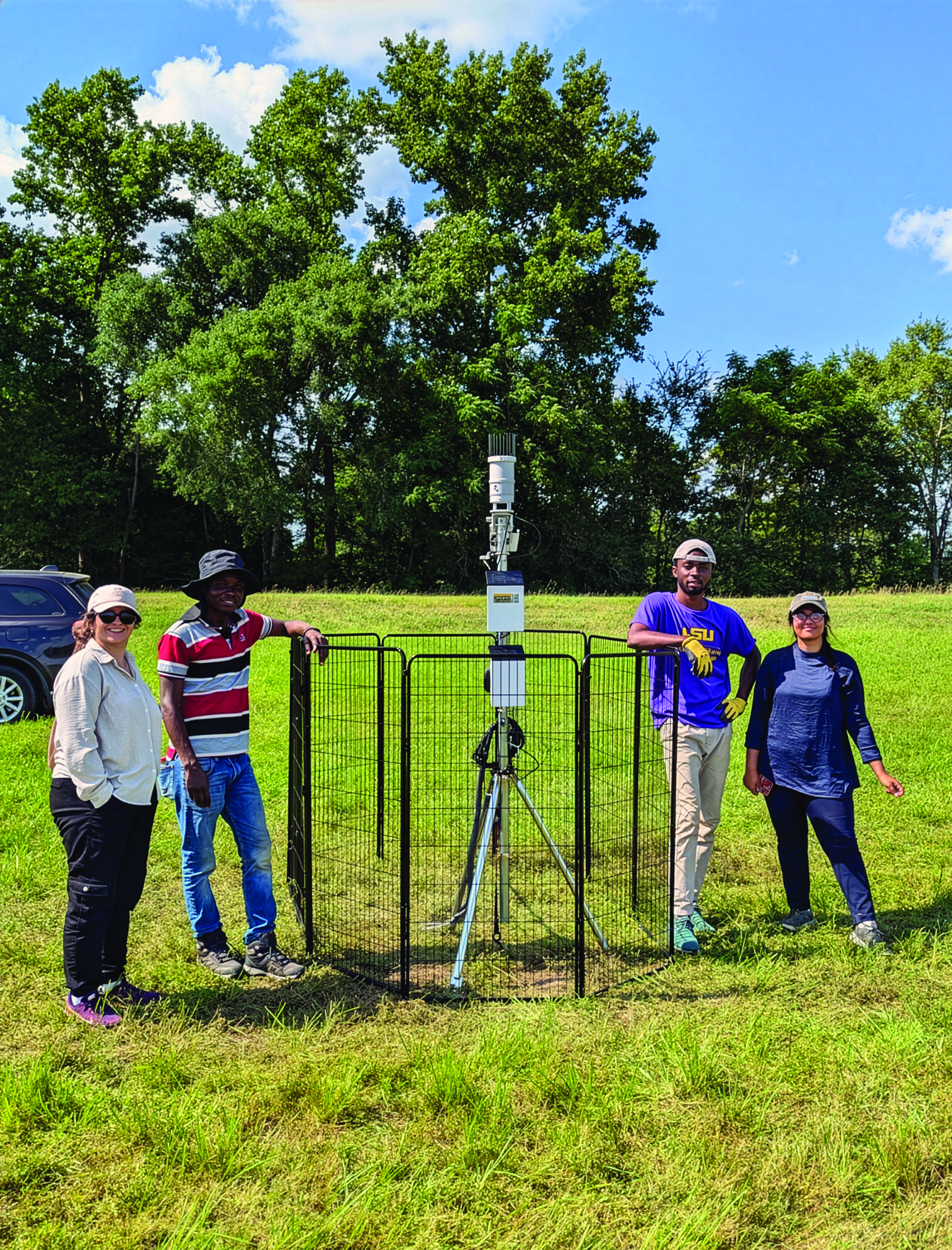
A LaCADIAN field station is shown during a project team visit at the LSU AgCenter Macon Ridge Research Station in Winnsboro. Photo by Vinit Sehgal

The LaCADIAN weather station consists of an ATMOS 41 automated weather station with a normalized difference vegetation index (NDVI) sensor, an infrared thermometer and ZL6 data loggers. Below ground, along the soil profile, TEROS 12 sensors measure soil water content, temperature and electrical conductivity, while TEROS 21 sensors measure soil matric potential, indicating how tightly water is held in the soil and its availability for plant uptake. Graphic by Vinit Sehgal.

A drone sprays herbicide on Palmer amaranth infesting soybeans in an integrated weed management program using unmanned aerial vehicle-based multispectral imaging. Photo by Prashant Jha